Sunday, July 24, 2011

Australia Aid

1. Done 

2.
  • Economic growth, not foreign aid, is overcoming long-term poverty in the world.
  • The amount in which Australia spends on overseas has doubled over the last two years and it predicted to double again. By 2015 Australia will be spending over $8billion a year helping people overseas.
  • So it seemed like a good idea when Kevin Rudd announced a review of Australia's overseas aid program the report is about how to allocate and administer all the extra money. But neither the panel or the government could answer the main question asked about our aid program and the reason it's growing so fast.
  • Spending money in ways that make difference doesn't help anyone. 
  • Of course some aid really does help. Most obviously, emergency relief after disasters such as Indonesia's tsunami can save thousands. But this accounts for only 7 per cent of today's program.
  •  The majority of our aid is supposed to help overcome long-term poverty.
  • A billion people still live on less than $1.25 a day. 
  • Poverty is being overcome. In 1981, 54 per cent of the world's people lived in extreme poverty. 2005 this had fallen to 25 per cent. In 2015 it will be less than 15 per cent.
  • Any act of charity is, among other things, an assertion of power. Perhaps as power slips away, we feel more need to assert it.
The Author of this article has put forward some interesting points and statistics, and the overall feeling of this article is that Australia's aid program is kinda pointless as the countries that Australia are helping do not  necessarily need it, and can look after ourselves.   

3.
I think that Australia is giving more aid each year as the government believes they are in a better economic state than other countries, or to prove the Australia is becoming a powerful country. This allows Australia to build good relations with other countries. But with the good there is the bad as this now means that there is money not going into the Australian society, that they could spend on other things in Australia to make it a better place.

Monday, May 9, 2011

Mapping

1. What is it about the pressure system stalled over Australia that relates to the weather over the next 4 days?
The pressure system over Australia is High in the next 4 days there for being the weather is likely to be cold. 
2. What is the air pressure in each of the next 4 days for each of the capital cities? How does this correspond with the predicted weather for these cities?

City
Thursday
Friday
Saturday
Sunday

Sydney
1016 Mostly Sunny 
1020 Sunny
1020 Sunny
1017 Mostly Sunny 
Melbourne
1024 Mostly Sunny 
1026 Sunny 
1025 Sunny
1017 Mostly Sunny 
Adelaide
1030 Sunny 
1030 Sunny
1025 Sunny
1024 Sunny

Darwin
1012 Cloudy 
1017 Partly Cloudy 
1008 Sunny 
1008 Sunny 
Perth
1024 Sunny 
1024 Sunny 
1024 Sunny
1016 Partly Cloudy 
Brisbane
1016 Partly Cloudy 
1016 Partly Cloudy
1020 Sunny 
1017 Raining 


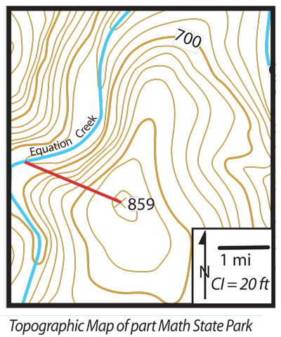
1. The contour interval is the difference in altitude represented by the space between two   contour lines on a map. Contour interval = 20f which converts to 6.096 metres
     2. The scale of the map is 1.6km to every cm 
    3. The gradient of the map is 0.01125m

9.2 Questions

1. The development of the railway system in Sydney and and also the building of the Sydney harbour bridge enabled the city to expand to centres into the west like Liverpool and Parramatta

2. Many of the manufacturing and industrial activities are being replaced by new technology and information-based industries. This is affecting the employment structure of Sydney

3. A world city is a city that has been deemed to be an important node (or swelling) point in the global economic system. This is being proved by Sydney quickly becoming invaded by new technology and information-based industries

4. New land releases in the north-west and south-west are required. These are called Greenfield locations. These sites will accommodate 30% of future growth. Many sites inside the city have also been targeted for urban renewal and urban redevelopment through urban consolidation.

5. A Metropolitan Strategy names "City of Cities. A Plan for Sydney's Future"

6. The state government of NSW was responsible for this plan

7.
-ensuring economic, social and environmental sustainability
-manage issues surrounding urban growth
- manage issues concerning decline

8. A Greenfield site is a term used to describe undeveloped land in a city or rural area either used for agriculture, landscape design, or left to naturally evolve. This is different because completely new infrastructure must be built, whereas urban consolidation is using existing infrastructure.

9. 70% of the future population growth in Sydney will be absorbed into the existing developed areas of Sydney, whereas 30% will be moved into the Greenfield sites

10. Many council and community groups were consulted in the development in this strategy. This was important as it was necessary to know what the views of the general population were.

11.
Refer to 9.8:
a.       1994-1995

b.      1989-1990

c.       Urban growth started to declined slowly

d.      The trend for urban development is expected to reverse, and start to rise.


12.
Refer to 9.10:
a.       The population density of North Sydney and Sydney is a lot higher than that of Liverpool and Penrith. This would be because Liverpool and Penrith are further away from the city and the coast line.
b.      The Ocean
c.       Urban housing would heighten the population density while residential housing would lessen the population density

13. 
Greenfield site:
Location: North-West growth centre
Main aspects : happening in the local government areas of Baulkham hills, Blacktown, The Blue Mountains, Hawkesbury and Penrith, 60 000 new homes will be developed. Strong community focus planned for this area.

Sydney Site:
Location: East Darling Harbour
Main aspects: it is the last remaining port at Darling Harbour is to be developed following a government decision to move the shipping to other port areas. The renewal of the site will feature an 11-hectare waterfront park.

Wednesday, March 23, 2011

Jordan Springs

1.  Is this an example of urban consolidation or urban sprawl? Why?
It is an example of urban sprawl, as it is a new development not extending an existing infrastructure. It is made 7km out of Penrith so its out of the way and made on a mass land. It holds 2500 homes. 


2. Do you think that this development is positive or negative for the surrounding community? For Sydney? For Australia? 
I believe it can be positive as it creates job opportunities for trade workers, however it also pull people out of the surrounding suburbs, therefore could also have a negative impact. 

9.1 Questions 1 - 12

Questions 1 - 12 


Q1. Urban Sprawl - a characteristic of Australian cities where population growth has caused expansion outwards in size with the creation of new low-density suburbs

Q2. Urban Consolidation - the redevelopment of parts of a city to achieve a higher population density, characterised by high-rise apartment complexes and villa developments

Q3. A highly urbanised county is one that has a highly populated areas

Q4.

Sydney:
Population - 3 502 000

Melbourne:
Population - 3 162 000

Brisbane:
Population - 1 508 000

Q5. A factor that influences our capital cities is that they are all near the sea so this allows for easy transport.

Q6.
Population Density - The number of people per square kilometre
Urban Sprawl -  A characteristic of Australian cities where population growth has caused expansion outwards in size with the creation of new low-density suburbs

Q7. Australian cities have a low population density in comparison to other countries, however our population is still rising so this is due to change in the coming years.

Q8. Major infrastructure are already in use but with urban sprawl they will be used more than ever before.

Q9. Urban planers are making original designs now to assist with problem of urban sprawl. 


Q10. 
a. Melbourne 
b. Its is calculated by dividing the population of the country to the square density
c. High
d. 3 out of 10 


Q11. The noise the construction will make, however does bring money into community 


Q12. More freedom, more room to live.

Sunday, March 13, 2011

Urban Renew and Decay


  • File:Royal.crescent.aerial.bath.arp.jpg
  • Aesthetics
  • Definition -  the branch of philosophy dealing with beauty and taste, "is it aesthetically pleasing" how something looks.
This image is Aesthetically pleasing, as it is a building that looks good.


Safety

Definition - the state of being certain that adverse effects will not be caused by some agent under defined conditions 
This image shows safety, as the high walls around this town give it a sense of safety to the people in the town.


Slums

Definition - a run-down area of a city characterized by substandard housing and squalor and lacking in tenure security. 
This image shows the state of what some slums are like and how run down the areas are.


Urban Decay
Urban Decay
Definition - Urban decay is a process by which a city, or a part of a city, falls into a state of disrepair and neglect. 
This image is an example of urban decay, it shows and building that is basically falling apart and has been neglected.


Reconstruction and renewal 
Definition - Areas devastated by war or invasion challenge urban planners. Resources are scarce. The existing population has needs. 
This image shows a new building plan or a reconstructed city.


Transport 
Definition - Transport within urbanized areas presents unique problems. The density of an urban environment increases traffic, which can harm businesses and increase pollution unless properly managed. 
This image shows the a station, this is an option of transport over cars.


Suburbanization 
Definition - In some countries, declining satisfaction with the urban environment is held to blame for continuing migration to smaller towns and rural areas.
This image shows that although an important factor, there is a complex relationship between urban densities and 
car use


Environmental Factors 
Definition - Environmental protection and conservation are of utmost importance to many planning systems across the world.
This image shows a tightly compacted suburb with little to no trees. 


Light and Sound 
Definition - The urban canyon effect is a colloquial, non-scientific term referring to street space bordered by very high buildings. 
This image shows the effect of light. 

Wednesday, March 9, 2011

Coastal Management - The Tweed River Entrance Sand Bypassing Project

Questions 1 - 9 page 167


Q1. Why did it become necessary to extend the Tweed River breakwaters?
The breakwater on the southern side of the Tweed River acted to trap sand that would naturally be moved in a northerly direction by longshore drift. The continual build‑up of sand on the southern side of the breakwater eventually caused the river mouth silt up and cause a blockage. 


Q2. What impact would the construction of the breakwaters have had on the replenishment of sand to the Gold Coast beaches after severe storm erosion?
The construction of breakwaters will cause the beaches on the Gold coast to loose sand due to longshore drift and the beach will be unable to naturally get their sand back, as it will but getting stuck at the river entrance.

Q 3. Why did the Tweed River become unsafe to shipping? Explain the natural process that caused sandbars to form over the mouth of the Tweed River.
The Tweed River became unsafe for shipping because of sand bars building up in the River mouth making it shallow so the ships will run aground in the mouth so they had to stop shipping in the Tweed River. 


Q4. Why was the dredging of the Tweed River and the associated beach nourishment program only a short-term solution to coastal management of the area?
It was only a short term coastal management as the barriers were not big enough so the sand built up over time and therefore had to rebuild them again. 


Q5. Describe the way the TRESBP replaces the natural process of longshore drift.
The TRESBP replaces the natural process known as longshore drift in the construction of breakwaters. This construction breaks the drift of the ocean when it hits the beach as it cannot go past the wall of rock.


Q6. Write a paragraph that explains your opinion of the TRESBP. Why do you think the project is regarded as one of the most successful coastal management schemes in Australia?
I believe the TRESBP is one of the most successful projects in Australia for a few reasons. Firstly because the intended aim of the project was to stop silting at the mouth of the Tweed River and to stop the formation of a sand bar. 
The construction of breakwaters was the best thing that could have been done and did work in stopping the silting – temporarily. It gives developers an idea on what they should do the future, which may be even more beneficial and less costly.

Q7. Draw an annotated map to explain the operation of the TRESBP.
In the Book on page 167


Q8. Look at the aerial photographs in 7.28. Describe the changes that have occurred to the mouth of the Tweed River since 1962.
1962 – In this image it makes it very clear why the Tweed River mouth became a problem for silting up with sand, as the mouth is so open and unprotected from any thing it becomes very vulnerable to clogging up.


1969 – The construction of the breakwaters has opened the Tweed River heads and caused the beach to shift position. There is more sand on the surrounding beaches as the process of dredging has also taken place. however the river mouth looks alot cleaner and deeper therefore looks like it is working.


1994 – The breakwaters haven’t really changed but the amount of sand on the surrounding beaches has increased dramatically. Fairly soon a new solution will need to be put in place as the sand will reach the edge of the breakwater and will once again, begin to form a sandbar.


Q9. Using the topographic map in 7.25 on page 164, estimate the length of the breakwater along the Tweed River entrance in 1962 and in 1994.
In the topographic map the length of the breakwater is approximately 350 metres in 1994. 


Monday, March 7, 2011

Summarising the TRESB Project

The problem which lead to the TRESB Project.
The problem that lead to the TRESB project is that the shipping path in which the boats would go in and out of, was continually filling up with sand a other stuff that was moving northwards from the beaches. 

The solution to the problem.
In solution to this problem, barriers were put into place to allow the sand to build up near the enterance. This sand is then moved up the coast where it will no longer be affecting the river.
The result of the project. What areas were effected and how? Do you think that it was a success?
As a result of the project, beaches on the gold coast were affected because of the sand was being caught up in the rivers and the sand from the beaches was slowly going away.
However this project was a success because of the way that it solved the problem of the blockage of the Tweed River. 

Sunday, February 20, 2011

The Science of Big Waves

Pre-viewing:

1. Where do ocean waves come from? What gets them started?
Ocean waves come the deep sea, and they get started by currents

2. What do you think a surfer should know about waves before they try and ride a wave while surfing?
they should know the way the form and what the waves are likely to do and how quickly they can change

Question for the Video:
1. Observe all the waves that you see and describe how they form and break. Use as many words found in the segment for you descriptions.
After watching this video on big waves, the way that these big waves break is that they either crash from the middle of the wave and roll eitgher way leading a huge tube fo the surfers to ride, or the are a massive rolling wave with alot of white water rolling behind the surfer. 

2.Describe how waves are formed, how they originate, and how they are measured?
Waves are formed wind speed wind direction and size of the fetch. They are measured from crest to crest (peak to peak), they are formed out to sea and get bigger as the hit to reef.

3.What is a maverick wave and what is special about the way it is formed?
A marverick wave is a big wave and it is special beacuse it is formed way out at sea and gradually gets bigger, and as it hits the reef gets alot bigger. However for mavericks to work it needs the correct wind direction and swell direction.

4. How is energy stored and transferred during wave?
It is stored underneath, in the deep water, and the explodes up as the water gets shallower.

5. List any kind of advice given by the surfers about how to survive these “big waves.”
- Respect the waves
- Ger in there, catch one, before the wrath of the gods comes down on you

Year 10: 7.3 Geographical Processes Shaping the Coastal Environment

Wave Refraction

Tombolo
Beach

Coastal Lagoon
Barrier Dune System
Sand Spit 
 Offshore Sand Bar
Sand Dunes
Sea Cave
Natural Bridge
Sea Stacks
Longshore Drift


Wednesday, February 9, 2011

Year 10: 7.1 Geographical Issues in the Coastal Environment

Will Hennessy

1. People are moving away from the cities and into the coastal area.

2. So the coast line doesnt move up into the developped areas.

3. sea change was the trend of people moving from the city to small coastal towns.

4. government responce to sea change was to put a cap on the amount of people able to move to the coast.

5.
Population growth - people moving from cites to the small coastal change

Pollution - the human actions that cause this issue are that people are not carefully disposing items and that poeple need to take more care prtecting our oceans from pollutions.

Tourism and recreational pressures - the coast is a high tourist attraction and during peak season these populated beaches can double in population and due to this the beaches can be distoyed. e.g a beach that has four wheel driving on the dunes as an attration can be highly susceptible to erosion if not looked after.

Coastal rivers and lagooons - these places need to be constantly cleaned and looked after as the boats pollution can be harm full and the silt that can be flushed through then can block up the entrance so if not mangage correcttly looked after.

6. the role geographers play in developing is that they can find problems and then find a solutions to this problem.

7. Inappropiate development
dear editor,
i'm finally please with the governments efforts to make our coastline sustainable for a better coastal future, they have finaly started making changes and restirctions on the develpoment aloung the coastline and introducing managment stategies increases the jobs in the smaller towns.